… using years of evidence and observation to design safer streets that move people more efficiently, in particular improving public transit options.
I have a keen interest in transportation issues, and 7 years of experience running the Ward 32 Transportation Committee has given me many insights into various transportation issues in our area. For the record, every single week I bike, take transit, and drive my car. So I am sensitive to concerns regarding all modes of transportation.
I have conducted multiple transit and traffic studies, sitting on corners for hours, recording the movement of transit and traffic. I was consistently encouraged by residents who saw me sitting in my folding chair with my clipboard.
I have also obtained many of the city’s various traffic studies from around the area, learning how the city uses them to make decisions.
There is much that can be done to improve safety and efficient movement of people in our ward, and I have concrete and well-researched solutions to these issues.
Ward 32 Transportation Committee
The Ward 32 Transportation Committee sprung out of Councillor McMahon’s first town halls in early 2011.
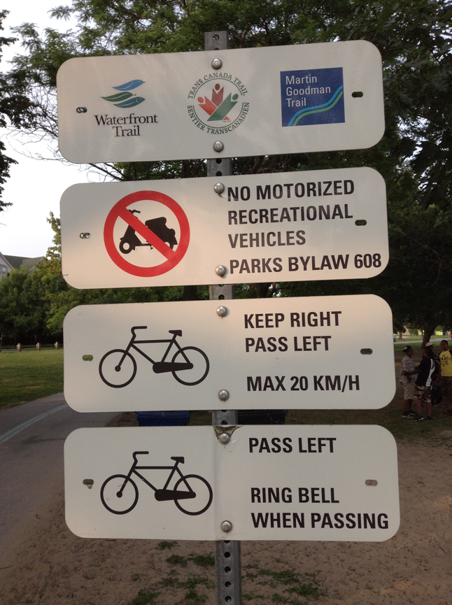
Our first success in improving safety was our report on “Improving Safety and Awareness on the Martin Goodman Trail” and it prompted the city to add new signage and ground markings in the eastern portion of the MGT.
Of course, we advocated for more ground markings and larger signs than the city was willing to shell out for, but it was still a vast improvement over the total lack of such things.
STUDIES AND REPORTS:
Over the next 7 years with the help of various volunteers, we did multiple studies:
- Two transit studies
- A traffic study on Queen
- A traffic study for residents in the Cassels area, after the Woodbine cycle track caused an influx of traffic on side streets.
I have also written and submitted reports to the city and council, such as “Improving the Woodbine Cycle Track”, “Mitigating the Impacts of Transportation Infrastructure”, and “Illegal Trucks on Woodbine and Prioritizing Highway 2”.
In addition to this, as administrator of the Facebook page, I have done my best to share up-to-date transportation information with the community.
As councillor, I will ensure that information on transportation disruptions are communicated to the community as promptly as possible, and will continue to study and measure transportation in the area.
Pedestrians
Whether you bike, transit, or drive, everyone becomes a pedestrian at some point. Our intersections could be designed much better, to ensure pedestrian safety and improve accessibility.
There is an ironic paradox in the design of our intersections, as they are simultaneously too cookie-cutter, and yet also wildly inconsistent. How can a vision-impaired person navigate our streets when our pedestrian push buttons are positioned differently at every intersection?
CROSSWALKS:
The vast majority of intersections on our side streets lack proper ground markings and curb cuts to clearly show pedestrian crossings.
As well, at many stop signs, the line on which to stop is missing.
Ground markings are not just a guide to create space for different kinds of road users, they also increase awareness in general.
Pedestrians and cars know their spaces and can interact safely within them.
Proper curb cuts are also essential to accessibility. I cannot tell you how often I am walking my son in his stroller and there is no indication as to where is the safest, easiest place to cross an intersection.
As councillor I will work towards all intersections having clear and obvious ground markings and curb cuts.
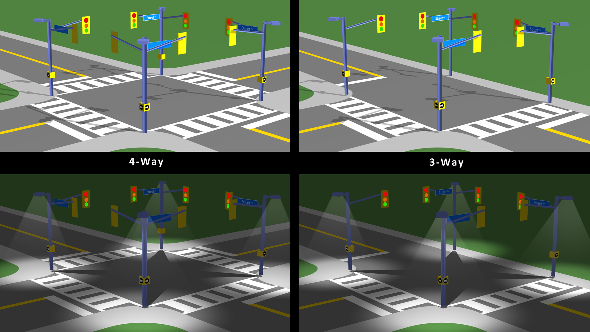
THREE-WAY INTERSECTIONS:
There is one aspect of vehicle-pedestrian conflict that is very common in our area, and that is three-way traffic light intersections.
Unless dealing with the level of pedestrian volume we see downtown, there is no reason to have two parallel pedestrian crosswalks at a three-way intersection—one will do.
If we remove the crosswalk that blocks left turning vehicles, not only does it remove a potential conflict of a driver trying to make their left turn in the path of a pedestrian, it will also improve the movement of vehicles by never having to worry about pedestrians crossing on that side.
These revelations came to me after watching the Woodbine-Norway intersection go up.
The only thing the community wanted was a crosswalk, instead we got a bunch of grey traffic poles going up next to existing poles (some less than 6 feet away). Some poles were only there for the push button, and traffic lights are now blocking people’s windows.
I detail those issues in a report I sent to all of council.
RIGHT TURNS AND PEDESTRIANS:
There have also been concerns in the area about right-turning cars hopping the curb where pedestrians are standing.
I have never presented this idea previously (see diagram below), because I never had time to properly research it. But I think a redesign of our intersections is in order.
My design would solve a few problems:
- It creates a physical barrier that protects pedestrians at corners.
- It makes it easier for the vision-impaired to find the push buttons and feel the direction they are pointing.
- It can greatly reduce the number of poles and infrastructure to hold everything needed at an intersection, reducing both cost, materials, and labour time.
As councillor, I will influence the city to adopt new strategies to improve pedestrian safety and to question the standards and methods we use to build intersections, so we can devise a better solution.
Cycling
As our climate warms and our streets have nowhere to expand, cycling is becoming an increasingly important transportation option.
It is imperative that we create safe spaces for cyclists, not just for their sake, but also so car drivers have less to worry about.
WOODBINE CYCLE TRACK:
An important report was “Improving the Woodbine Cycle Track” (technically and legally it’s not actually a bike lane). Here are its recommendations:
- Add an eastbound left turn signal and a southbound right turn signal at Kingston and Woodbine
- Make the signage and ground markings at intersections consistent and clear
- Reduce Woodbine to 40km/hr
- Relocate or better signage for the Bike Share station at Woodbine Station
- Add planters/bumpouts/bollards to bookend the permanent parking spaces
Some fellow residents and I were able to meet with city officials from transportation services and the TTC. I won’t rehash details here, the full history is contained in the report.
They agreed with some of the findings, but have yet to do anything about them. The most important issue they disagreed with, however, is the new configuration of Kingston and Woodbine.
On the southbound side, cars are encouraged to illegally use the right-turn-only lane to go straight through, around people turning left.
In addition to encouraging illegal behaviour, this also creates more conflict with cyclists travelling through the intersection.
I documented this ongoing behaviour in the video below.
A southbound left turn lane would solve all of this, but the city has prioritized moving northbound rush hour traffic through the intersection.
They refuse to add a southbound left turn lane, instead opting to ban left turns for a longer period of time. This in turn drives traffic onto Heyworth Cres.—a tiny street with an elementary school bordering it.
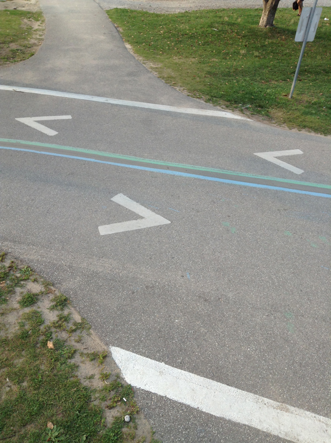
I also documented one of the flaws that even city staff agreed was a problem: the confusing and contradictory signage and ground markings at intersections.
The report details this in depth, but basically, the visuals to direct car and bike behaviour are in conflict with each other, and are causing people to improperly turn right from the straight-through lane when they should be sharing the curb lane with bicycles.
It’s also causing cyclists to mistakenly get angry with car drivers for using that portion of the road, even though they are entitled to it.
Signage needs to be intuitive, consistent, and easily understood at a glance, not the hodge-podge of confusion and contradiction we have now.
BIKE LANES:
The ONLY new bike lane I would support as councillor would be on the Danforth.
There is ample room for it and high demand, as there are numerous cyclists commuting along it every day.
Many people ask why bike lanes can’t be pushed onto side streets and the answer is simple: because there are no destinations there.
A commuting cyclist is going to need to use a major avenue at some point, whether it’s because that’s where most destinations are located, or because it’s the only place to cross certain geographical barriers like train tracks or the DVP.
Simply put, cyclists are on major avenues for the exact same reasons car drivers are: because it gets them to where they need to go.
Providing cyclists with a safe space in which to ride is proven to reduce conflicts and tragedy on streets.
CAN-BIKE:
We need better education on both sides of the fence.
I believe Can-Bike, the Canadian Cycling Association’s official cycling course, should be taught in Grades 7 and 8. The aspects of it that relate to cars should be part of drivers’ education as well.
What makes me a safe cyclist with only one near accident (and two almost-doorings) after a lifetime of cycling in Toronto, is being a car driver first and being able to predict the behaviour of cars.
Part of the problem with cyclists is that their behaviour is much more unpredictable and inconsistent than cars; many cyclists just go with their gut rather than any particular philosophy of safe riding.
Can-Bike teaches cyclists predictable riding, which makes it easier for cars to know what to expect when sharing the road with cyclists.
Obviously, when driving a two-tonne vehicle, the onus is on drivers to be watching what they are doing. But there is ignorance on both sides in terms of the rules, which is compounded by the city’s inconsistent, confusing, and at times contradictory ground markings and signage at intersections.
As councillor, I will support the city’s plans to create a connected bicycle route network and will strive to make more safe spaces for cyclists on our roads.
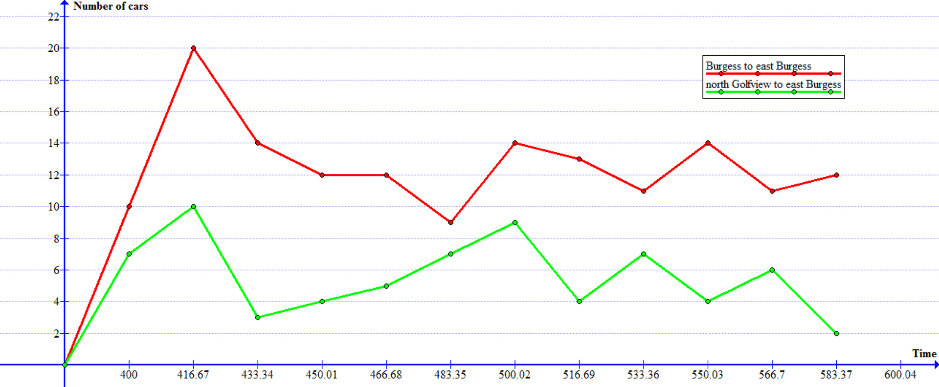
Transit
Our ward is unique in how many surface transit routes terminate here.
The 501, 502/503, 506, 22, 64, 92, 12, all have end points in our ward.
This can be good or bad: good because closer to the start of a route you’re more likely to get a seat, bad because any problems farther up the line mean transit gets cut off with no alternative.
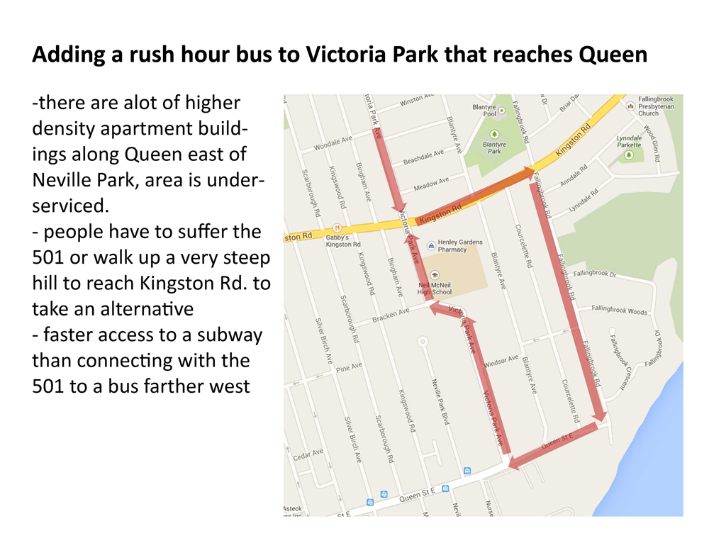
NEVILLE PARK:
Neville Park is actually a “transit desert” as there are quite a few apartment buildings there, but only one transit option—the 501.
Worse, if someone who lives at Neville Park needs to go north or east on transit, they must first go west on the 501 to then cut north on the 64. An idea I floated to the city years ago is a rush-hour-only Victoria Park bus to connect with the 501 at Queen.
REGULAR SERVICE:
One of the main issues with transit in our area is regularity, especially on routes like the 501.
While there are traffic issues downtown that can delay the 501 greatly, there is also a lack of accountability or monitoring of streetcars as they pass through the Neville Loop—especially late at night.
In a past transit study, we found that the bunching and gapping of streetcars during morning rush hour heading into the Neville Loop was the same going in as going out.
This means that instead of using the Neville Loop as a valve to space out transit regularly, streetcars simply go in and out, with problematic bunching and gapping remaining.
The city says this will be solved by the new streetcars, as they will have technology to keep them better spaced apart, but they said that many years ago and Bombardier still has not come through while the issue persists.
The problem could easily be solved with a bit of administration, as all TTC vehicles can be tracked with their GPS.
However, when I asked former TTC chief customer officer Chris Upfold why they don’t have a better “air traffic control” for the TTC, he replied simply that there isn’t enough money. When new money comes in, the choice is usually between spending money and time to eventually create such a system, or buy some new buses now and improve service immediately.
It is this kind of band-aid thinking that is forced upon public services because of a lack of money to do the job properly.
As councillor, I will work with the TTC to better understand the complexities of scheduling the transit system and push for improvements that will lead to more regular and reliable service.
A Transportation Network
Another problem plaguing the decisions of experts in the city is not having the resources to take a more holistic approach to transportation issues.
Unfortunately, they tend to focus on streets and intersections in isolation, while using very few variables to make decisions. They’ve also told me that they do not take a macro-view of the larger transportation network, and do not make decisions specifically to change vehicle behaviour.
TRAFFIC VS TRANSIT:
One example is how they use their level-of-service (LOS) traffic studies to determine the timing of lights.
They do a traffic count at an intersection, and if there are cars that did not make it through a light before it turns red, that direction of the intersection is deemed to be over capacity.
This all seems reasonable until one realizes that in their traffic counts, 1 streetcar full of 100+ people is counted the same as 1 car with 1 person in it. The city does recognize this, and has given streetcars the ability to delay a light turning red by 30 sec.
But that doesn’t really address the flaw in the approach, nor is it always a solution. Their models are designed to move vehicles, not people.
PARKING RESTRICTIONS:
Another example is the decision by the city to expand evening rush hour parking restrictions on Queen St., in order to speed up streetcar service.
They ignored all other variables, and only focused on streetcar travel times in the worst case scenario of the slowest recorded week.
A solution that is tailored to only the worst case scenario is unavoidably going to be an extreme solution.
I met with a staffer from transportation services, and as we strolled along Queen St., I tried my best to impress upon him that the time of year they picked is not only during the beginning of the busier summer time, it’s also the time when schools get out and parents flock to pick up their kids.
So the slowdown in traffic may not be improved by losing parking for longer.
I also implored him to consider the impact on our businesses, which for better or worse, depend on parking. Lack of parking on Queen St. is one of the biggest complaints from shoppers.
Lastly, I also did my own traffic study to show them when the actual peaks in traffic were (as opposed to only measuring streetcar times from GPS data).
To no avail, the city would not be moved, not even when a board member of the Beach Village BIA testified at Beaches-East York Community Council.
Street parking availability is also an ongoing complaint on busy avenues like Queen. Years ago I did an audit of all street parking on Queen and there is space to add parking in many areas.
SIDE STREET TRAFFIC:
There is an ongoing issue throughout the ward, pre-dating the Woodbine cycle track, but worsened by it—through traffic using side streets to cut through to another street faster.
This has made streets less safe, with traffic rushing through and ignoring signs. This has also triggered many requests for speed humps and other measures to mitigate the traffic.
I conducted a traffic study for the Cassels area, and one of the participants wrote about it for the Beach Metro (unfortunately the article is not online).
We devised a few potential solutions, like adding some one-ways or planters that make certain streets exit only—but residents were divided.
Cars cannot be prevented from entering a public street. Yellow signs that say “no through traffic” are actually unenforceable, they are used simply as a scare tactic.
The only solution is to make the side streets either an nonviable route or a less attractive option. The best way to do this without changing the side streets themselves, is to improve traffic flow on major avenues.
CREATING A TRANSPORTATION NETWORK:
In my studying of the area, I have a solid vision of how to create a more fluid transportation network. I wrote one report on properly utilizing Kingston Rd, and I have a plan for Coxwell that goes with it.
The basic idea is to conform rush hour parking restrictions on Kingston and Coxwell, to create two solid channels for traffic to flow through. I also think the city should have created a two-lane roundabout to solve the issues at Woodbine and O’Connor.
Roundabouts are safer and keep a constant flow of traffic, but with their recent changes, that is not likely.
I have been deep into transportation issues for many years, and as councillor I would ensure a more holistic approach to transportation thinking that sees the streets as a larger network, and creates a safer more efficient environment for all road users.